FIJIANFijian HistoryHISTORY
  • Privacy Policy
  • About Us
  • ‹
  • 1
  • 2
  • 3
  • 4
  • 5
  • ›
“Fijians – clothing, Village People (Suva area), probably taken during [18]80s” Source: Fiji Museum P32.4/138
Origins of Suva

The indigenous settlement of Suva was established in the early 1800s at the site of the present-day Thurston Gardens. The itaukei were forced to move to Suvavou in 1882 by European colonial powers to make room for the new capital. 

“A small child, possibly the Governor’s son, Jack, seated on a pony with two Fijian attendants in front of Government House in Nasova, Ovalau Island, Fiji”. Source: collected by A. von Hügel, 1875-77, Museum of archaeology and anthropology, P.99680.VH, http://maa.cam.ac.uk/photo-government-house-p-99680-vh/
Government House

Government House was the residence of the British Colonial Governors of Fiji since 1892 and was rebuilt after a lightning strike in 1921. Today it is known as the Presidential Palace.

“Boys Grammar School postcard”, Co-operative (W.J.B. Stinsone), c.1930s? Source: http://www.justpacific.com/fiji/fijiphotos/grammar/bgs3.jpg
Suva Grammar School

The original Suva Grammar School was built in 1917 on Victoria Parade specifically for European boys. Girls were educated at another building on Selbourne Street a year later. Suva Grammar School is a co-ed school currently located at Nasese.

“Borron House overlooking the Waimanu Road area, around 1942” Source: Time Connections: A Quarterly Newsletter from the Friends of the Fiji Museum, 1996
Borron House

Borron House was once the home of a wealthy colonial planter family and is now used as a state guesthouse by the Government of Fiji to accommodate VIP guests.

“Great Council of Chiefs, Waikava”. Senior members of the Great Council of Chiefs with Cakobau seated at the top of the ramp above his brother Ratu Josefa Celua. The chief to his left, wearing a white masi turban is likely Musudroka, the Vunivalu of Rewa. Waikava, Vanua Levu, Fiji. Possibly photographed by F. Dufty, December 1876. P.99842.VH Source: http://maa.cam.ac.uk/photo-great-council-of-chiefs-p-99842-vh/
Great Council of Chiefs

The Bose Levu Vakaturaga was a formal gathering of Fiji's indigenous (iTaukei) chiefs. It was established by the British Colonial Government in 1875 as an advisory body and named the Council of Chiefs (the term “Great” was added sometime later in the twentieth century). The complex at Draiba was completed in 2009 for Council meetings but was destroyed by fire ten years later. The North and South wings of the complex house the Ministry of iTaukei Affairs, Ministry of Lands and Ministry of Foreign Affairs. 

“Artist’s rendering the Grand Pacific created for the Union Steamship Company” Source: http://grandpacifichotel.com.fj/about-us/
Grand Pacific Hotel

The Grand Pacific Hotel is one of the oldest hotels in the Pacific. It was built in 1914 to offer a more luxurious style of accommodation for cruise ship tourists. It was recently renovated and extended but it retains many of its original colonial architectural designs.  

“Landing of the Southern Cross at Albert Park, 1928”, Source: http://suvacity.org/albert-park /
Albert Park

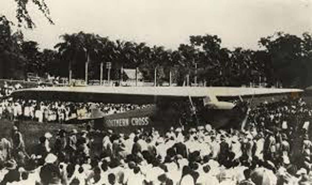
Albert Park was constructed as a cricket ground in the 1880s on land that once belonged to the indigenous village of Suva. It has since hosted sporting events, national celebrations, visiting dignitaries, and was the site of the first airplane landing in Fiji in 1928.
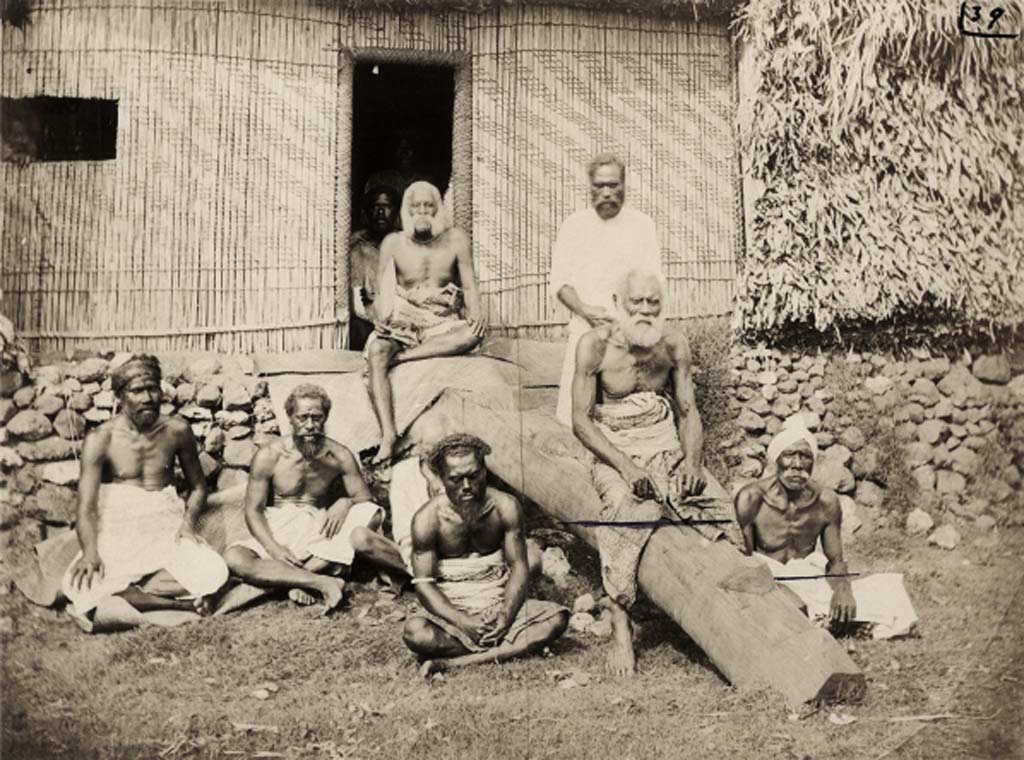
“The burenivanua in the centre of Sorokoba. The house is the official residence of the Tui Ba. It was rebuilt according to traditional designs atop the original yavu, but with modern materials” Source: Nicholas halter 2018.
Sorokoba Village, Ba

Sorokoba is located 3km north of Ba town and is the seat of the Tui Ba (paramount chief of Ba).

“Early Suva: Fijian market, Basil Thomson collection c1892” Source: Fiji Museum 1/2/6.13E/23
Suva Municipal Market

The market has been a vibrant meeting place for Suva residents and visitors to buy fresh fruit and vegetables, meat, fish, yaqona and traditional wares. The original Suva market was located near Pier Street, next to the Queen’s Wharf. It was moved to Cumming Street in the early 1900s until a new market was constructed at the present location between Harris Road and Rodwell Road in 1949.

  • ‹
  • 1
  • 2
  • 3
  • 4
  • 5
  • ›
Attribution-NonCommercial

Website content is licensed under a Creative Commons Attribution 4.0 International License. All material used on this site retains the original Creative Commons Licences and can only be re-used under their respective licences. Note that corporate logos (such as the Fijian History logo) and images used in some collections and branding are specifically excluded from the Creative Commons Attribution Licence, and may not be reproduced under any circumstances without the express written permission of the copyright holders.

Fijian History © 2018 - The University of the South Pacific
About

This project was a collaborative effort by staff and students of The University of the South Pacific to document some of the historic sites of Fiji.

Download App

Download the app from Google Play Store and browse fijian stories even when offline

Get the app on Google Play
Contact
  • Email us